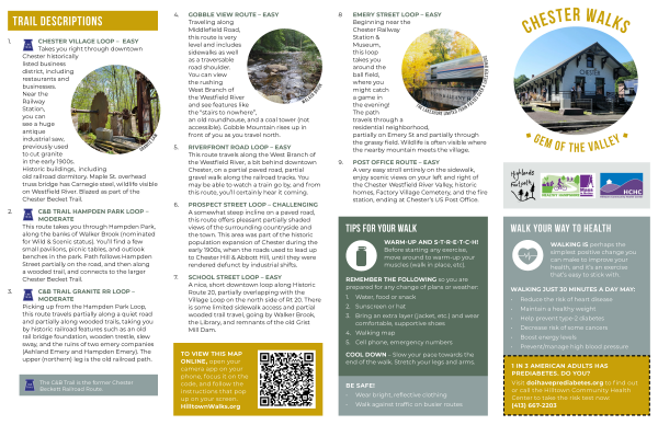
A HIKE ALONG THE KEYSTONE ARCH BRIDGES TRAIL
Click the Hiker and print this guide for your hike
___________________________________________________________________________
2021
The KAB Trail not only takes one to the first series of stone arch railroad bridges built in America but tracks the first National Wild & Scenic River and the longest stretch of free-flowing river in MA, all within the states’
largest
roadless wilderness.
This unmatched historic and environmental experience is 90% within the town of Middlefield and Hampshire County, with portions in Chester; Hampden County and Becket; Berkshire County.
The trail is accessed from Herbert Cross Rd, off Middlefield Rd. in Chester. Park by the kiosk and begin walking. At the bottom of the hill, bear to the left, following Babcock Brook to its confluence with the Westfield River.
Looming
above you will be the 45-foot-high double arch bridge. This bridge is wholly within the boundaries of Chester/ Hampden Co. It is still in use and shares a unique 5 keystone cluster feature with the Bancroft Arch, the only other
bridge
completely within the boundary of a single town and the only other example still crossed by trains.
The double and the Bancroft Arches bracket the historic district. The Bancroft Arch is not on the trail, but can be accessed via Town Hill Rd. It is completely in Middlefield since it spans Factory Brook, and not the Westfield
River. From
Chester west, The Westfield River is the boundary between Becket and Middlefield, causing the remaining Arches to be half in each town and county. Return to Herbert Cross Rd. and continue west.
This hike is one of escalating returns. The farther you go; the spans are subsequently higher, larger and more inspiring than those that came before. We strongly recommend utilizing the ancillary trails at each bridge to descend to
the
river level. Only by looking up at them can their true majesty be fully appreciated. In about a mile, you will intersect with an abandoned section of the original 1841 alignment, circumvented in 1910 to ease a sharp curve preceding
this
portion of the route and adding a third track. A left will take you to the top of the 65-foot arch. You will see the present-day CSX line on the other side of the valley.
Continuing westward along the abandoned roadbed, the traveler will encounter on the left, a massive retaining wall constructed by the same immigrant stonemasons who built the Arches. This extends down about 50 feet to the riverbank
and
keeps the right of way from collapsing into the river. This wall has an intrinsic splendor all its own.
While negotiating a 60-foot-deep hand-hewn cut through the mountainside, look for the long concave marks in the rock. These were made by the two-man churn drills. One held the 5 ft. long iron drill and turned it a quarter turn
between
sledgehammer blows by the second worker.
A bit farther along you will notice concrete blocks on each side of the trail. These were bases for semaphore signals placed here around 1900 and represent the most modern upgrades before this segment was cast off. The woods begin
to open
to the sky as you come onto the 70-foot-high Arch. This bridge sports massive wing walls, some gently curving through the forest for up to 300 ft.
Observation of this bridge from water level is a must. It is truly the crescendo of the hike. This is a breathtaking structure, brilliantly revealing its ancestry in the great cathedrals of the Old World.
Ascending back to the former track gradient, continue for another ¼ mile westward, and carefully work your way to the edge of the 70 foot drop off where the trail leads to the left and the CSX active rail line. You are on the
approach of
a long gone Arch, probably removed during the railroad bypass project. Through the trees on the opposite bank, you will be rewarded with a unique view of the interior design of these majestic structures. A more modern concrete arch
bridge
stands to the left of this ruin. Here the trail ends.
Return the way you came in. Entering the active CSX rail line is illegal and dangerous. After re-crossing the 70-foot Arch, leave the trail and venture into the woods on your left. You will notice that the hillside has been hollowed
out
where tons of schist was quarried to construct wing walls and any structure components that did not require cutting, as did the stones used in the arch structures. You will find a massive boulder the immigrant workmen were
attempting to
split with feather drills, when it broke in the wrong direction. Closer inspection will reveal a drill still embedded in the rock.
Stones used in the arch support structures were all cut from Chester Blue granite quarried elsewhere. Some of this quarrying occurred along Town Hill Rd., about a mile north of the Bancroft Arch. Careful examination of the hillside
there
will reveal it to be, a mountain of rip rap.

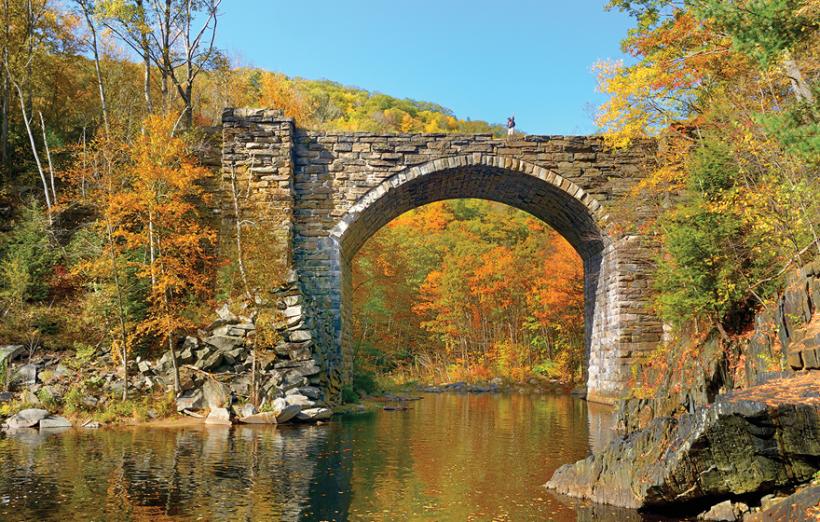
Keystone Arches Designated National Historic Landmark
Two keystone arch bridges located on MassWildlife's Walnut Hill Wildlife Management Area
in Middlefield and Becket have been named National Historic Landmarks.
Two keystone arch bridges located within MassWildlife's Walnut Hill Wildlife Management Area (WMA)
in Middlefield and Becket were recently designated as National Historic Landmarks
by the U.S. Department of Interior (DOI).
Soaring above the
West Branch of the Westfield River, the bridges are an intact segment of the country’s first railroad built to pass over a mountain. The two bridges are part of a series of area stone railroad bridges built for the Western Railroad that
ran
from Boston to Albany. Major George Washington Whistler is credited with the design and implementation of an unprecedented plan to extend the rail through the central Berkshires by spanning the West Branch of the Westfield River in
multiple
locations. With only 2,500 National Historic Landmarks in the entire country, this prestigious designation recognizes the structures' significant place in United States history. The federal designation was the result of a combined
effort of
cultural and conservation partners. An application for Landmark designation to the DOI was filed in 2013 by the Friends of the Keystone Arches and the Wild and Scenic Westfield River Committee with a unanimous endorsement by
MassWildlife's
Fisheries and Wildlife Board.
Anyone willing to do a little hiking can experience some spectacular examples of architecture and railroad history in a beautiful natural setting. In addition to the arches, visitors can enjoy the state's longest free flowing waterway
situated in one of the largest blocks of undeveloped landscapes in the region. The West Branch of the Westfield River, a National Wild and Scenic River, is popular among anglers fishing for wild and stocked trout and for experienced
kayakers
paddling the river rapids. The WMA includes exemplary forested communities of northern woodlands, rich mesic forest, and hickory-hop hornbeam in various stages of growth. Walnut Hill WMA offers excellent opportunities for deer, bear,
and
turkey hunting. Wildlife viewing prospects include forest dwelling birds such as thrushes, warblers, and woodpeckers. Minks and otters patrol the waterways along with aquatic insects; mayflies, damselflies, and dragonflies. Several
state-listed species of rare plants and insects have also been documented on the property.
In an era of human and horsepower, construction of the 150-mile railroad was completed by 3,000 laborers in an incredible two and a half years, opening in 1841. The group of arched bridges located near and within the remote 900+ acre
Walnut
Hill WMA can be accessed via the 2.5 mile one way Keystone Arch Bridge Trail in Chester. The trail is maintained by the Friends of the Keystone Arches with the permission of MassWildlife. The nearby Chester Factory Village Depot in
Chester
was also grantedNational Historic Landmark status. Visitors can stop by the Western Railroad museum in Chester to learn more about the national engineering marvel that the bridges represented at the time.
MassWildlife's mission to protect wildlife lands across the state has been remarkably successful. Thanks to an unusual partnership, at Walnut Hill WMA the conserved land and water comes with a spectacular added cultural benefit, sure to
be
appreciated by all who visit.

MASSWILDLIFE
___________________________________________________________________________
The Keystone Arches are a series of stone arch bridges built in 1840, when the railways
of eastern Massachusetts and
Albany New York were connected.
They are located in three Massachusetts Towns:
Becket, Middlefield and Chester, and
three Massachusetts Counties:
Berkshire, Hampshire and Hampden.
To walk the entire trail, plan on a 5 mile hike. One way from start to finish is approximately a 2.5 mile hike on our cleared trail.
___________________________________________________________________________
The Official Chester Walk Brochure 2023
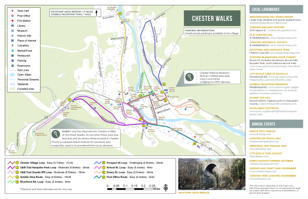
Click the above image for the official two page MAP and Legend page
Friends of the Keystone Arches and/or The Chester Foundation (pick one)
participated on the committee that created this Chester Walks map
Three of the loops comprise the
Chester & Becket Trail created by the Friends of the Keystone Arches.
This trail showcases the contribution of the Chester & Becket Railroad which
connected the Becket quarries with two finishing works on the valley floor in Chester.
This single track line operated from 1897 to 1930, when trucks were substituted.
A section of the line highlights the remains of a wooden trestle on the
JJ Kelly Wildlife Conservation Area off Hampden St. in Chester.
This trail has been blazed thanks to a grant from Healthy Hampshire,
but awaits a crosswalk and the re-surfacing of Hampden St. in 2019
to be fully open and functional.
An 'Urban Loop' of the C & B Trail leads visitors through the Historically
Listed Downtown Chester Business District, terminating at Chester Station
across the street from the Granite Saw, one of the facilities served by the branch.
Visit our sister site:
The Chester Railway Station and Museum
___________________________________________________________________________
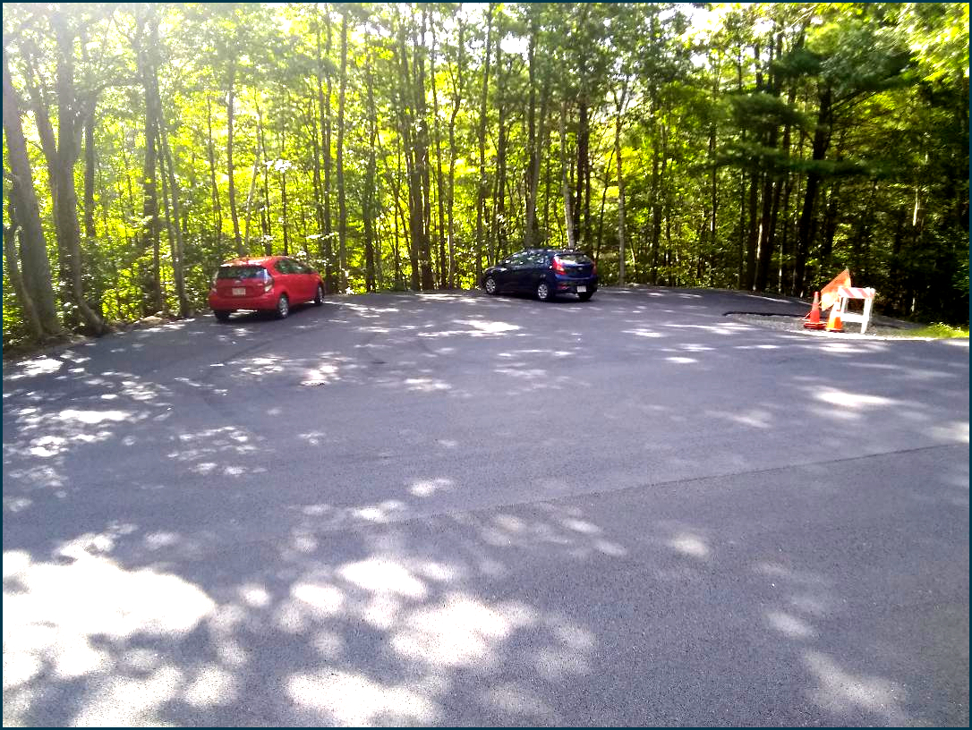
We are happy to announce expanded and paved parking area at the
trailhead to the Keystone Arch Bridges Trail,
thanks to the Chester Highway Dept.
GPS 42.31147, -72.99262
___________________________________________________________________________
Read about our Volunteers and accomplishments.
Sunrise and Sunset Times
___________________________________________________________________________
Visit our sister site:
The Chester Railway Station and Museum
___________________________________________________________________________
Our Contact: